


GR4 (3)

chasle
Gebruiker

Lengte
13,6 km

Max. hoogte
1162 m

Positief hoogteverschil
1116 m
Km-Effort
27 km

Min. hoogte
456 m

Negatief hoogteverschil
716 m
Boucle
Neen
Datum van aanmaak :
2019-01-16 00:07:59.603
Laatste wijziging :
2019-01-16 00:08:47.361
5h37
Moeilijkheid : Zeer moeilijk

Gratisgps-wandelapplicatie
 SityTrail
IGN / Geografische instituten
SityTrail Plus
De wereld gaat voor u open
Over ons
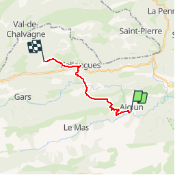
Tocht Stappen van 13,6 km beschikbaar op Provence-Alpes-Côte d'Azur, Alpes-Maritimes, Le Mas. Deze tocht wordt voorgesteld door chasle.
Plaatsbepaling
Land:
France
Regio :
Provence-Alpes-Côte d'Azur
Departement/Provincie :
Alpes-Maritimes
Gemeente :
Le Mas
Locatie:
Unknown
Vertrek:(Dec)
Vertrek:(UTM)
332292 ; 4857733 (32T) N.
Opmerkingen